Some deliveries may take a little longer than usual due to regional shipping conditions.

DOWNLOAD THE APP


Customer Services
Copyright © 2025 Desertcart Holdings Limited
DOWNLOAD THE APP

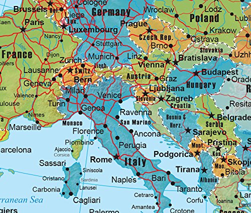
🗺️ Elevate your space with Europe’s most dynamic wall map—where knowledge meets style!
The Europe Wall Map GeoPolitical Edition by Swiftmaps is an 18x22 laminated map combining detailed political boundaries with a 3D-shaded physical relief layer. Crafted on heavy-duty paper with durable 3mil lamination, it offers vibrant, long-lasting visuals ideal for education, business, or decor. Updated annually to reflect current geopolitical data, this map ensures accuracy and style, backed by a full satisfaction guarantee.
| Customer Reviews | 4.6 4.6 out of 5 stars (607) |
P**R
Perfect for students
Perfect map for students, especially!! However, I’m a Grandmom, and find it fascinating.
D**.
A+
The European wall map arrived via a tube, so after carefully rolling the tube shape the opposite way, it straightened out perfectly. With the help of some Blu Tack, it easily mounted on a piece of thin black art board. The colors are vivid, with clear print for the capital of each country, and a few other towns/cities marked as well. The size fits just right on my art room door, and the print is large enough that looking up towns or cities doesn't require using a magnifier. It is perfect for my needs.
A**R
Satisfied!
Good lightweight and coated map now hanging on my wall and used daily to map current events.
B**A
Came quickly.
Not much detail. Can't find Wales.
M**O
My parents came from Italy..
I bought it to explain to my friends where my parents were from and where I lived for 10 years. Very accurate.
T**R
Excellent
This very much helped me to turn my ignorance of the middle east to search for more knowledge of this area
E**E
The bigger picture
In presentation about Ukraine and NATO, this map was perfect.
J**N
Map of Europe large size
Now I can follow where my grandson is stationed. Couldn’t do that with a regular size map.
L**A
Muy util
D**Y
Great
A**R
This map is great for planning trips to have visual as to the other areas to visit when booking a main location.
D**Y
Clear and colourful map. I stuck it on my wall with blue tack. Looks great.
V**E
Très bien tres
Trustpilot
3 days ago
1 month ago