Description
🌍 Explore boldly, stay connected globally — your ultimate adventure GPS!
- RUGGED READY - Waterproof, impact-resistant design built to withstand the harshest environments — because your gear should be as tough as you.
- NAVIGATE LIKE A PRO - Preloaded TopoActive maps plus satellite imagery and multi-band GNSS ensure pinpoint accuracy in any terrain.
- SMART OUTDOOR COMPANION - Sync with Garmin Explore app and your smartphone for live weather updates, geocaching, and seamless trip planning.
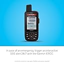
- STAY CONNECTED ANYWHERE - Two-way messaging & SOS via global Iridium satellite network keeps you linked even off-grid.
- UNMATCHED BATTERY ENDURANCE - Up to 425 hours in expedition mode means multi-day adventures without the worry of power loss.
The Garmin GPSMAP 67i is a rugged handheld GPS device featuring a 3-inch sunlight-readable color display, global two-way satellite messaging via the Iridium network, and an interactive SOS function linked to a 24/7 emergency response center. It comes preloaded with TopoActive maps and supports premium map downloads via Wi-Fi. With multi-band GNSS support, built-in sensors, and up to 425 hours of battery life in expedition mode, it’s engineered for serious outdoor enthusiasts who demand reliable navigation and communication in the most remote locations.